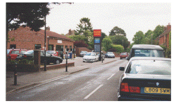
 The
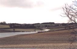
"river" looking towards Luton
The
"river" looking towards LutonKIMPTON
VILLAGE YEAR 2001
RE-EMERGENCE
OF RIVER KYM, FEBRUARY 2001
The
"river" looking towards Luton
photograph
courtesy Catherine Tees
Kimpton
Village is built along the course of the former River Kym or Kyme which it is
thought flowed down what is now Claggy Road and the High Street to the River
Mimram, halfway between Kimpton and Codicote.
The river is known to have appeared briefly in 1947 but in February 2001,
due to an unprecedented amount of rainfall since the previous September, it
emerged again followed its natural course from Netherfield Springs (near
Breachwood Green), through Kimpton, to join the Mimram at Kimpton Mill.
There is very little information about earlier floods, but the following
was found in a Parish Magazine:
Copied
from Kimpton Parish Magazine No. 147 of 1895
KIMPTON
IN 1795 (extracted from the parish records) - Severe frost for six weeks. Wheat
at 9/6 per bushel. The frost began to break on February 8th; the thermometer in
a room had been as low as 20degrees. On Monday, February 9th, there was a flood
in Kimpton in consequence of the thaw and the impenetrability of the ground. The
low road at the bottom of the vicarage gate to within a furlong of Kimpton mill,
a length of two miles, had all the appearance of a powerful river: not the least
part of the road could be seen. The melting snow upon the higher ground poured
down upon the road in various rapid currents and formed a body of water in some
places four feet deep, but in general two feet deep throughout the whole length
of the road. One half of the houses in Kimpton were twenty inches deep in water.
No horse could stand against the current in safety. Timber trees that lay on the
side of the road of considerable size were whirled round and carried down the
stream. General consternation prevailed amongst the inhabitants on the south
side of the road for their furniture, which could with difficulty be saved.
About 7 p.m. it began to abate after a continuance of twenty-eight hours. About
three the following morn it had quite subsided. All that day the inhabitants
were busy in recovering their floated property, and in mending the torn up
roads.
The
following account of the disaster is taken mainly from a North Herts District
Council report to the Executive Committee:
![]()
The
source seemed to come from a spring
about 8km north west of Kimpton and the water from it flowed down the valley,
fed by other springs, along the route of the old River Kym until, by the time it
reached the Industrial Units on Claggy Road and the north west end of Kimpton,
the flow was in the region of 1,000,000 gallons per day
.
As
the water flowed down the valley it collected in natural and man-made hollows in
the ground forming lakes of various sizes.
The largest of these was situated at Whiteway Bottom where the road known
as The Causeway crossed the valley on an embankment approximately 2 - 2.5 m
high. Water had collected upstream
of the embankment and formed a lake which was estimated to contain approximately
3,000,000 gallons. Another,
smaller, lake formed further down the valley at The Holt. The water from the two lakes flowed over the respective roads
and continued down the valley to Kimpton, the lowest point of the old river bed.
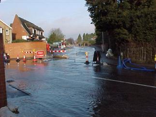
The
situation became serious over the week-end of the 24/25 February 2001 when the
business owners from the Industrial Estate and residents at risk in Claggy Road
hired pumps and called the Fire Brigade to try to deal with the water flow which
by this time had flooded the northern end of the Industrial Estate to a depth of
approx. 1metre. North Herts
District Council, the Police and Fire Service were all involved at this stage
and the situation was declared a Major Emergency by the Police.
photograph courtesy NHDC
The
flow of water was gradually brought under partial control by the use of pumps
and sandbag dams. The water was
diverted along Claggy Road to its junction with the High Street, where it flowed
across the junction and eventually flowed in to the water drainage system under
the road. This system carried the
water approximately 2 km east along the Codicote road to a balancing lagoon near
Kimpton Mill. A breach was made in the side of this lagoon to enable the surplus
water to flow over adjacent water meadows for 1/2 km, eventually discharging
into the River Mimram
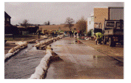
In
order for the village to carry on its daily business, a temporary bridge had to
be constructed across the "river" running alongside Claggy Road in
order to provide access to Commons Lane, and a small pedestrian bridge had to be
constructed to give access to the Corner Stores.
photograph
courtesy Ron Brooks
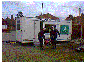
North
Herts District conducted regular meetings with the Parish Council and residents,
keeping everyone well informed of the situation. NHDC kept up 24 hour
surveillance for several months until the flow subsidised.
A temporary solution was devised to re-route the water which involved
piping it through the gardens of 5 residential properties, then under Park Lane
to the drainage system under the High Street.
Member
of Parliament Peter Lilley was involved and he managed to obtain funding from
the Government under the Bellwin system. The
total cost of the disaster was approximately £500,000, of which NHDC had to
find £24,000, the Government funding the remainder.
SALE
OF LAND AT WALKERS GARAGE
In
February the new vicar, Rev. Ken Buckler, was inaugurated and took up residence
with his wife and son in the vicarage at 11 High Street.